
Cadastral Surveyor: Role, Responsibilities & Importance in Land Surveying
A cadastral surveyor plays a vital role in defining, measuring and documenting land boundaries for legal and ownership purposes. In India, where land disputes and property documentation issues are common, the work of a cadastral surveyor becomes extremely important. From residential plots to agricultural land and commercial projects, accurate land measurement ensures legal clarity and smooth property transactions.
This blog explains what a cadastral surveyor does, why cadastral surveying is necessary, and how it supports land records, property registration and boundary demarcation.
What is a Cadastral Surveyor?
Cadastral surveyor is a licensed land surveying professional who is responsible for measuring land parcels and preparing official boundary maps used for legal documentation. The main purpose of a cadastral surveyor is to establish property boundaries and maintain accurate land records.
Cadastral surveying focuses on mapping land ownership details, plot dimensions and legal descriptions. These surveys are recorded in government land registries and are used for property taxation, land transfer, subdivision planning and dispute resolution.
In simple terms, a cadastral surveyor ensures that each piece of land has clearly defined and legally recognized boundaries.
Role of a Cadastral Surveyor in Land Surveying
The role of a cadastral surveyor goes beyond basic measurement. This includes legal knowledge, technical expertise and advanced survey tools.
A cadastral surveyor conducts boundary surveys to identify precise land boundaries. They verify existing land records, compare old maps with ground reality and correct discrepancies. In many cases, cadastral survey helps resolve property disputes between neighbors or land owners.
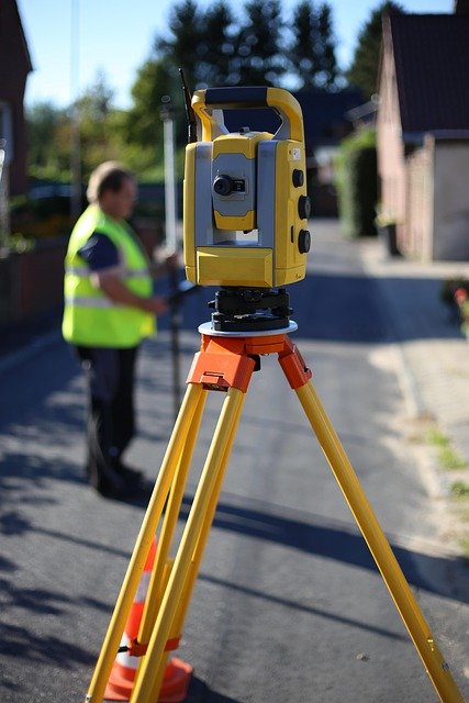
Modern survey use total stations, DGPS (Differential Global Positioning System), GPS equipment, and GIS mapping software to ensure high accuracy. These technologies improve accuracy in boundary demarcation and digital land mapping.
Importance of Cadastral Survey in Property Management
Cadastral survey is necessary for property ownership verification. Without accurate cadastral records, buying or selling land can be legally risky.
A cadastral surveyor provides certified maps that are required for property registration, land subdivision, construction approval and mutation processes. Government officials rely on cadastral survey data to maintain land revenue records and update ownership databases.
In infrastructure projects like highways, industrial development and housing schemes, cadastral survey ensures that land acquisition is done accurately and fairly.
Responsibilities of a Cadastral Surveyor
A professional cadastral surveyor performs many responsibilities related to land measurement and documentation.
Primary responsibility involves identifying and marking property boundaries using precision equipment. A cadastral surveyor prepares detailed survey reports and cadastral maps that show plot numbers, dimensions and ownership details.
They also coordinate with government departments, revenue officials and legal authorities to ensure compliance with land laws. In many cases, cadastral surveyors assist courts by providing technical evidence in land dispute cases.
Accuracy, attention to detail and knowledge of land regulations are the key qualities of a skilled cadastral surveyor.
Technologies Used by a Cadastral Survey
Modern cadastral surveying has evolved with advanced technology. Today, a cadastral surveyor uses total station instruments for accurate angle and distance measurements. DGPS technology provides high-accuracy positioning data, especially for large land parcels.
Geographic Information System (GIS) software helps to create digital cadastral maps and manage spatial data efficiently. Drone surveying technology is also becoming popular for capturing high-resolution aerial images of land parcels.
These technologies increase efficiency, reduce human error and improve the reliability of cadastral survey results.
Difference Between Cadastral Survey and Other Land Surveys
Many people confuse cadastral surveying with topographic or engineering surveys. However, the purpose of the cadastral surveyor is different.
Topographic surveying focuses on land features such as elevation, shape, and natural elements. An engineering survey supports construction projects. In contrast, cadastral surveying is primarily concerned with legal property boundaries and ownership records.
The work of a surveyor directly affects land ownership and property rights, making it legally significant.
Career Scope of a Cadastral Survey in India
The demand for cadastral survey is increasing due to rapid urban development and digitization of land records. Government projects like the Digital India Land Records Modernization Program (DILRMP) require professionals trained in cadastral surveying and GIS mapping.
Real estate companies, infrastructure developers and government departments actively employ qualified cadastral survey. With proper training in Total Station, DGPS, GPS and GIS, individuals can have a stable and rewarding career in land surveying.
Skill development in modern survey equipment and legal documentation increases job opportunities in both private and public sectors.
Conclusion
Cadastral surveyor is a key professional in the land surveying industry who is responsible for defining and documenting property boundaries. Cadastral surveying ensures legal clarity, prevents disputes, and supports property registration and land management systems.
With the integration of modern technologies like DGPS, GIS and drone surveying, the role of surveyor has become more advanced and accurate. Whether for residential, agricultural, or commercial land, cadastral survey remains the foundation of secure property ownership and reliable land records.